AIM
4/20/23
7
−
1
−
66
Meteorology
FIG 7
−
1
−
23
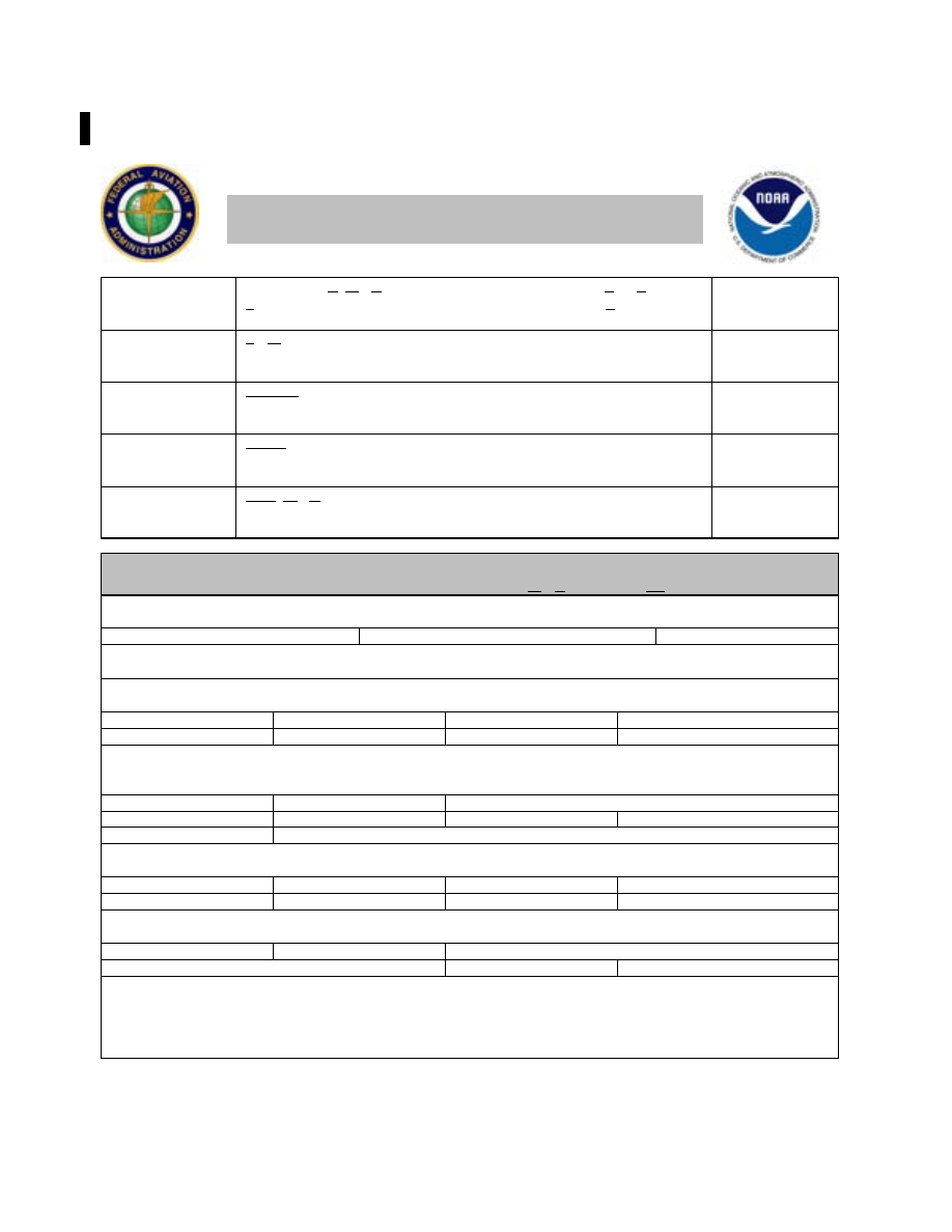
Key to Aerodrome Forecast (TAF) and Aviation Routine Weather Report (METAR) (Back)
Key to Aerodrome Forecast (TAF) and Aviation
Routine Weather Report (METAR) (Back)
In
METAR
, ReMarK indicator & remarks. For example: Sea- Level
Pressure in hectoPascals & tenths, as shown: 1004.5 hPa; Temp/dew-
point in tenths
°
C, as shown: temp. 18.2
°
C, dew-point 15.9
°
C
RMK SLP045
T01820159
FM091930
FroM: changes are expected at: 2-digit date, 2-digit hour, and 2-digit
minute beginning time: indicates significant change. Each FM starts on a
new line, indented 5 spaces
TEMPO
0920/0922
TEMPOrary: changes expected for <1 hour and in total, < half of the
period between the 2-digit date and 2-digit hour beginning, and 2-digit
date and 2-digit hour ending time
PROB30
1004/1007
PROBability and 2-digit percent (30 or 40): probable condition in the
period between the 2-digit date & 2-digit hour beginning time, and the
2-digit date and 2-digit hour ending time
BECMG
1013/1015
BECoMinG: change expected in the period between the 2-digit date and
2-digit hour beginning time, and the 2-digit date and 2-digit hour ending
time
Table of Significant Present, Forecast and Recent Weather - Grouped in categories and
used in the order listed below; or as needed in TAF, No Significant Weather.
Qualifiers
Intensity or Proximity
“-”
= Light
No sign
= Moderate
“+”
= Heavy
“VC”
= Vicinity, but not at aerodrome. In the US METAR, 5 to 10 SM from the point of observation. In the US
TAF, 5 to 10 SM from the center of the runway complex. Elsewhere, within 8000m.
Descriptor
BC
– Patches
BL
– Blowing
DR
– Drifting
FZ
– Freezing
MI
– Shallow
PR
– Partial
SH
– Showers
TS
– Thunderstorm
Weather Phenomena
Precipitation
DZ
– Drizzle
GR
– Hail
GS
– Small Hail/Snow Pellets
IC
– Ice Crystals
PL
– Ice Pellets
RA
– Rain
SG
– Snow Grains
SN
– Snow
UP
– Unknown Precipitation in automated observations
Obscuration
BR
– Mist (≥5/8SM)
DU
– Widespread Dust
FG
– Fog (<5/8SM)
FU
– Smoke
HZ
– Haze
PY
– Spray
SA
– Sand
VA
– Volcanic Ash
Other
DS
– Dust Storm
FC
– Funnel Cloud
+FC
– Tornado or Waterspout
PO
– Well developed dust or sand whirls
SQ
– Squall
SS
– Sandstorm
- Explanations in parentheses “()” indicate different worldwide practices.
- Ceiling is not specified; defined as the lowest broken or overcast layer, or the vertical visibility.
- NWS TAFs exclude BECMG groups and temperature forecasts, NWS TAFS do not use PROB in the first 9
hours of a TAF; NWS METARs exclude trend forecasts. US Military TAFs include Turbulence and Icing groups.