AIM
4/20/23
5
−
4
−
18
Arrival Procedures
FIG 5
−
4
−
11
Minimum Vectoring Altitude Charts
1500
2000
3000
3000
3000
3500
2500
5000
5500
5
10
15
20
25
30
348
013
057
102
160
250
277
289
N
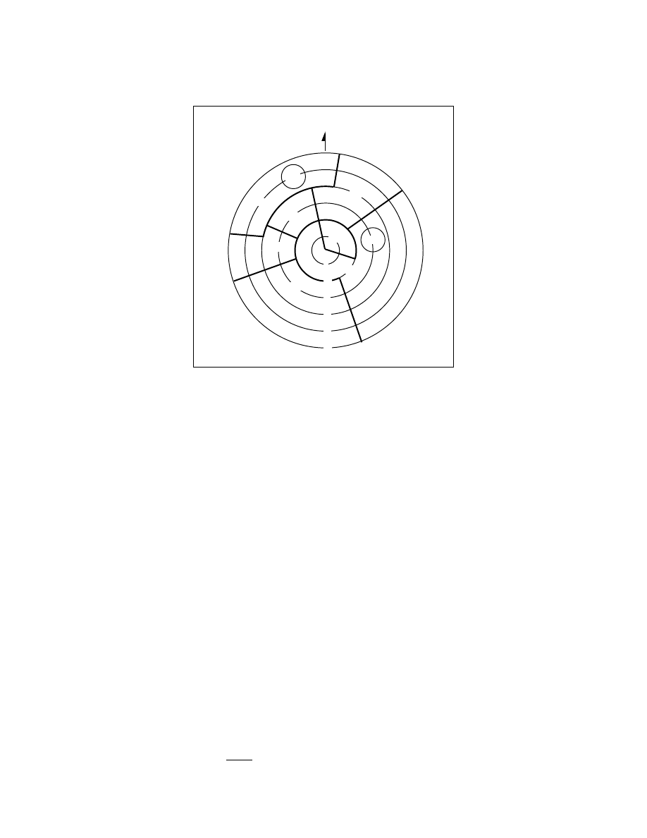
e. Minimum Vectoring Altitudes (MVAs)
are established for use by ATC when radar ATC is exercised.
MVA charts are prepared by air traffic facilities at locations where there are numerous different minimum IFR
altitudes. Each MVA chart has sectors large enough to accommodate vectoring of aircraft within the sector at
the MVA. Each sector boundary is at least 3 miles from the obstruction determining the MVA. To avoid a large
sector with an excessively high MVA due to an isolated prominent obstruction, the obstruction may be enclosed
in a buffer area whose boundaries are at least 3 miles from the obstruction. This is done to facilitate vectoring
around the obstruction. (See FIG 5
−
4
−
11.)
1.
The minimum vectoring altitude in each sector provides 1,000 feet above the highest obstacle in
nonmountainous areas and 2,000 feet above the highest obstacle in designated mountainous areas. Where lower
MVAs are required in designated mountainous areas to achieve compatibility with terminal routes or to permit
vectoring to an IAP, 1,000 feet of obstacle clearance may be authorized with the use of ATC surveillance. The
minimum vectoring altitude will provide at least 300 feet above the floor of controlled airspace.
NOTE
−
OROCA is a published altitude which provides 1,000 feet of terrain and obstruction clearance in the U.S. (2,000 feet of
clearance in designated mountainous areas). These altitudes are not assessed for NAVAID signal coverage, air traffic
control surveillance, or communications coverage, and are published for general situational awareness, flight planning and
in
−
flight contingency use.
2.
Because of differences in the areas considered for MVA, and those applied to other minimum altitudes,
and the ability to isolate specific obstacles, some MVAs may be lower than the nonradar Minimum En Route
Altitudes (MEAs), Minimum Obstruction Clearance Altitudes (MOCAs) or other minimum altitudes depicted
on charts for a given location. While being radar vectored, IFR altitude assignments by ATC will be at or above
MVA.
3.
The MVA/MIA may be lower than the TAA minimum altitude. If ATC has assigned an altitude to an
aircraft that is below the TAA minimum altitude, the aircraft will either be assigned an altitude to maintain until
established on a segment of a published route or instrument approach procedure, or climbed to the TAA altitude.
f. Circling.
Circling minimums charted on an RNAV (GPS) approach chart may be lower than the
LNAV/VNAV line of minima, but never lower than the LNAV line of minima (straight-in approach). Pilots may